For most of its pre-industrial life, Blue Anchor Lane was little more than a country track across Bermondsey marshland. British History Online’s Victoria County History records that the wider road was “called Blue Anchor Road in the middle of the 18th century and in 1871,” when buildings were still crowded only to the north, with grazing fields stretching outwards. An 1802 newspaper report already described “a Mr Spencer passing Blue Anchor Lane, Bermondsey” when he was robbed and beaten by footpads and left in a ditch — a vivid reminder that the lane was then still semi-rural and poorly lit.
c. 1695
First Record
Earliest recorded reference to the “Blew Anchor” tavern, on the first surviving map of the Bermondsey area.
1789
First Landlord
Sun Fire Office records Thomas Griffiths as victualler of the Blue Anchor — the earliest licensed landlord in the documentary record.
1802
Dark Lane
First press mention of the lane: a violent robbery reported on Blue Anchor Lane, suggesting it remained an unlit rural track.
1813
The Cannery
Donkin, Hall & Gamble establish the world’s first commercial canning factory on Blue Anchor Road, supplying the Royal Navy.
1836
First Railway
Spa Road station opens as London’s first railway terminus, on the viaduct immediately north of the lane.
1878
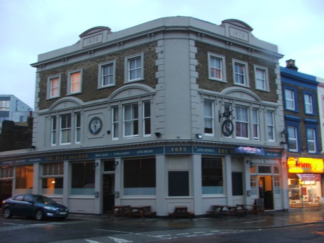
New Pub
The current Blue Anchor building is erected on the corner of the lane, replacing the earlier tavern on the same site.
1947
The Collision
A steam train collides with an electric train in heavy fog on the viaduct above Blue Anchor Lane; one injury reported.
The pivotal transformation came in the early nineteenth century, when engineer Bryan Donkin established a papermaking factory on what was then open land along Blue Anchor Road in 1802. By 1813, Donkin and his partners had launched a canning operation on the same road — the world’s first commercial cannery, supplying the Royal Navy and endorsed in writing by King George III. The factory later merged into the Crosse & Blackwell empire; its footprint is now occupied by the Harris Academy school on Southwark Park Road, where a commemorative plaque still survives.
The railway arrived next. Spa Road station — the original if brief terminus of the London and Greenwich Railway — opened on 8 February 1836, its platforms perched on the new brick viaduct that still straddles the northern end of Blue Anchor Lane. The viaduct changed the lane’s character permanently, creating the dark arched passage that defines the street to this day. The wider road was renamed Southwark Park Road in the late nineteenth century, but the lane itself retained the “Blue Anchor” designation, anchored to the tavern still standing on the corner.